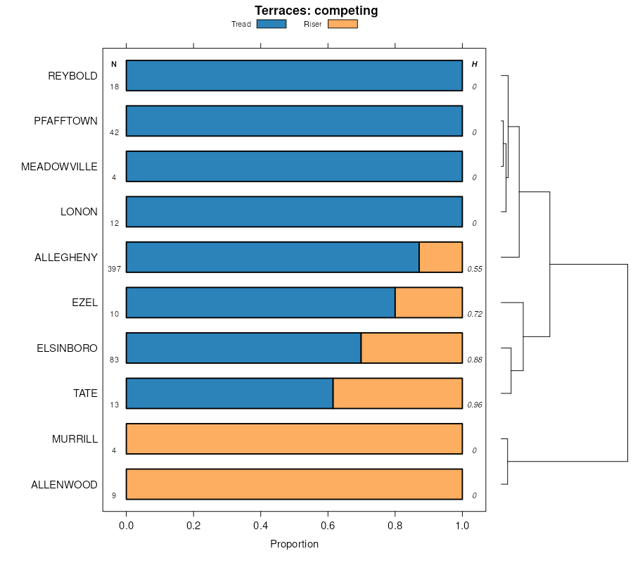
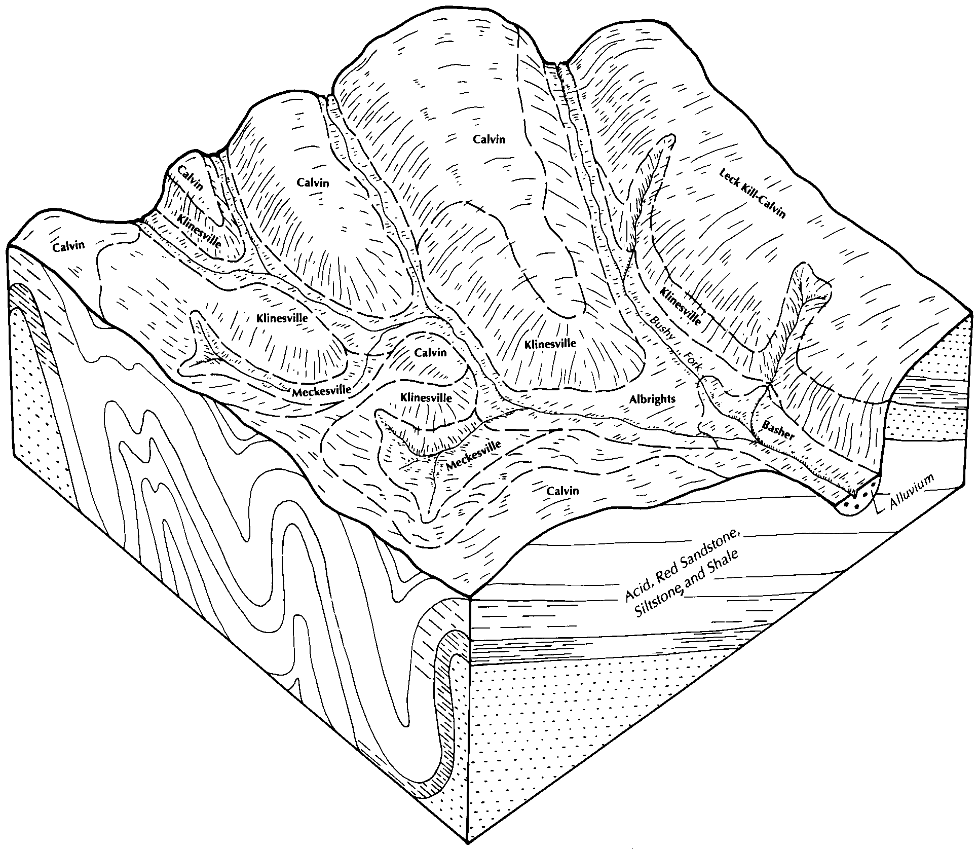
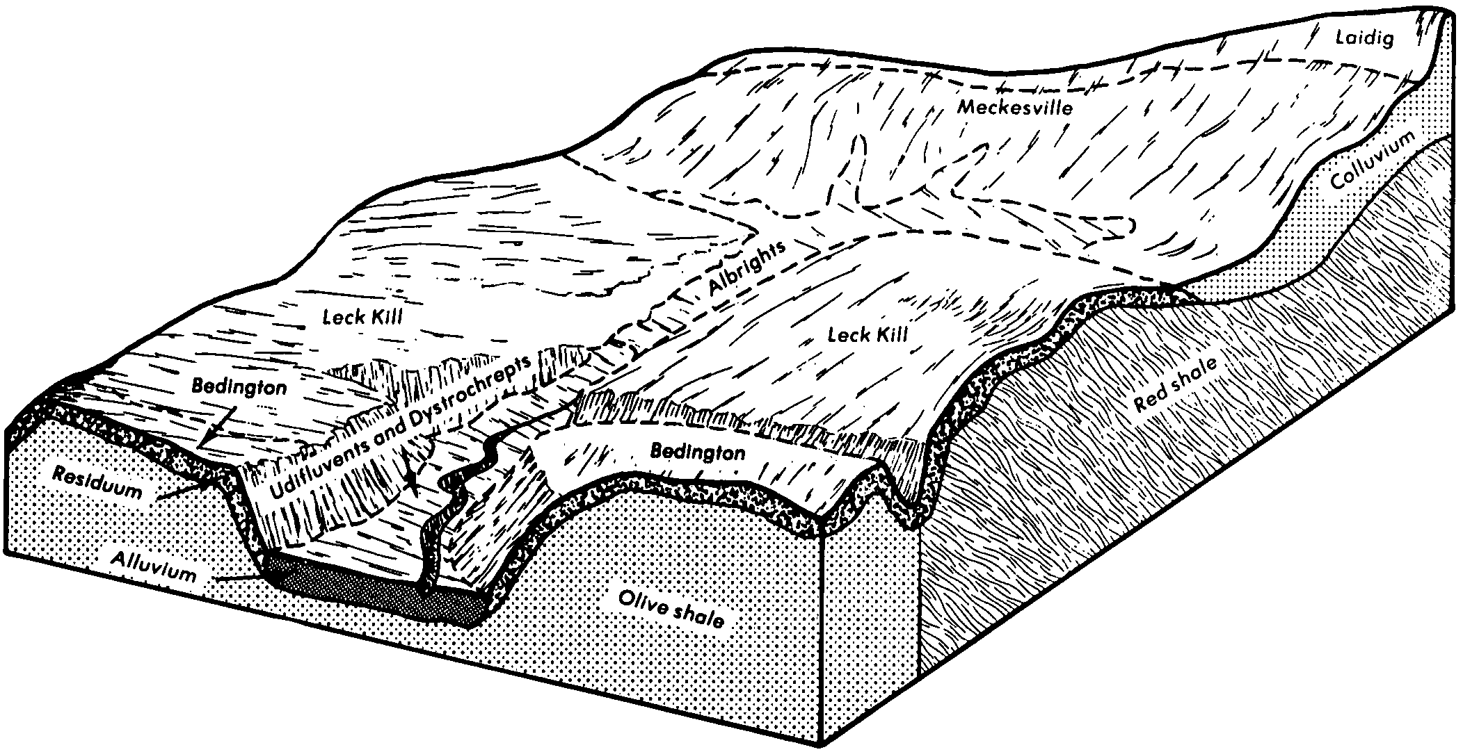
| Leck kill-Calvin complex, 8 to 15 percent slopes | LkC | 4867 | 541820 | l5t2 | pa009 | 1989 | 1:24000 |
Leck kill-Calvin complex, 15 to 25 percent slopes | LkD | 4607 | 541821 | l5t3 | pa009 | 1989 | 1:24000 |
Leck kill-Calvin complex, 3 to 8 percent slopes | LkB | 2366 | 541819 | l5t1 | pa009 | 1989 | 1:24000 |
Leck kill channery silt loam, 8 to 15 percent slopes | LeC | 12 | 541874 | l5vt | pa009 | 1989 | 1:24000 |
Leck kill channery silt loam, very steep | LLF | 7916 | 542366 | l6cp | pa013 | 1978 | 1:20000 |
Leck kill channery silt loam, 15 to 25 percent slopes | LkD | 4478 | 542375 | l6cz | pa013 | 1978 | 1:20000 |
Leck kill channery silt loam, 8 to 15 percent slopes | LkC | 3281 | 542374 | l6cy | pa013 | 1978 | 1:20000 |
Leck kill channery silt loam, 3 to 8 percent slopes | LkB | 1655 | 542373 | l6cx | pa013 | 1978 | 1:20000 |
Leck kill silt loam, 8 to 15 percent slopes | LkC | 559 | 541929 | l5xl | pa021 | 1978 | 1:20000 |
Leck kill silt loam, 15 to 25 percent slopes | LkD | 301 | 541930 | l5xm | pa021 | 1978 | 1:20000 |
Leck kill silt loam, 3 to 8 percent slopes | LkB | 284 | 541928 | l5xk | pa021 | 1978 | 1:20000 |
Leck kill very stony loam, 8 to 25 percent slopes | LkD | 6969 | 539363 | l37t | pa025 | 1960 | 1:20000 |
Leck kill channery silt loam, 3 to 8 percent slopes, moderately eroded | LeB2 | 2895 | 539357 | l37m | pa025 | 1960 | 1:20000 |
Leck kill channery silt loam, 8 to 15 percent slopes, moderately eroded | LeC2 | 2218 | 539358 | l37n | pa025 | 1960 | 1:20000 |
Leck kill very stony loam, 0 to 8 percent slopes | LkB | 1596 | 539362 | l37s | pa025 | 1960 | 1:20000 |
Leck kill very stony loam, 25 to 100 percent slopes | LkF | 1583 | 539364 | l37v | pa025 | 1960 | 1:20000 |
Leck kill channery silt loam, 8 to 15 percent slopes, severely eroded | LeC3 | 625 | 539359 | l37p | pa025 | 1960 | 1:20000 |
Leck kill channery silt loam, 15 to 25 percent slopes, severely eroded | LeD3 | 481 | 539361 | l37r | pa025 | 1960 | 1:20000 |
Leck kill channery silt loam, 15 to 25 percent slopes, moderately eroded | LeD2 | 324 | 539360 | l37q | pa025 | 1960 | 1:20000 |
Leck kill channery silt loam, 0 to 3 percent slopes | LeA | 218 | 539356 | l37l | pa025 | 1960 | 1:20000 |
Leck Kill and Calvin soils, steep | LMF | 15692 | 538297 | l24f | pa027 | 1975 | 1:20000 |
Leck Kill channery silt loam, 15 to 25 percent slopes | LkD | 6531 | 538305 | l24p | pa027 | 1975 | 1:20000 |
Leck Kill channery silt loam, 8 to 15 percent slopes | LkC | 4942 | 538304 | l24n | pa027 | 1975 | 1:20000 |
Leck Kill very stony silt loam, 8 to 25 percent slopes | LlD | 2228 | 538307 | l24r | pa027 | 1975 | 1:20000 |
Leck Kill channery silt loam, 3 to 8 percent slopes | LkB | 1293 | 538303 | l24m | pa027 | 1975 | 1:20000 |
Leck Kill very stony silt loam, 0 to 8 percent slopes | LlB | 367 | 538306 | l24q | pa027 | 1975 | 1:20000 |
Leck kill channery silt loam, 25 to 35 percent slopes | LkE | 1230 | 544052 | l842 | pa035 | 2002 | 1:24000 |
Leck kill channery silt loam, 15 to 25 percent slopes | LkD | 858 | 544050 | l840 | pa035 | 2002 | 1:24000 |
Leck kill channery silt loam, 8 to 15 percent slopes | LkC | 600 | 544048 | l83y | pa035 | 2002 | 1:24000 |
Leck kill channery silt loam, 3 to 8 percent slopes | LkB | 167 | 544046 | l83w | pa035 | 2002 | 1:24000 |
Leck kill channery silt loam, 8 to 25 percent slopes, very stony | LmD | 76 | 544054 | l844 | pa035 | 2002 | 1:24000 |
Leck kill channery silt loam, 3 to 12 percent slopes, moderately eroded | LkB2 | 14020 | 539508 | l3dh | pa037 | 1965 | 1:20000 |
Leck kill channery silt loam, deep, 3 to 12 percent slopes, moderately eroded | LlB2 | 10873 | 539514 | l3dp | pa037 | 1965 | 1:20000 |
Leck kill very stony silt loam, deep, 12 to 35 percent slopes | LmD | 5152 | 539518 | l3dt | pa037 | 1965 | 1:20000 |
Leck kill channery silt loam, 12 to 20 percent slopes, moderately eroded | LkC2 | 3963 | 539509 | l3dj | pa037 | 1965 | 1:20000 |
Leck kill very stony silt loam, deep, 35 to 60 percent slopes | LmE | 3909 | 539519 | l3dv | pa037 | 1965 | 1:20000 |
Klinesville and Leck Kill shaly silt loams, 35 to 70 percent slopes | KkE | 2629 | 539491 | l3cy | pa037 | 1965 | 1:20000 |
Klinesville and Leck Kill very stony silt loams, 35 to 100 percent slopes | KlF | 2598 | 539494 | l3d1 | pa037 | 1965 | 1:20000 |
Leck kill very stony silt loam, deep, 0 to 12 percent slopes | LmB | 2524 | 539517 | l3ds | pa037 | 1965 | 1:20000 |
Klinesville and Leck Kill very stony silt loams, 12 to 35 percent slopes | KlD | 1992 | 539493 | l3d0 | pa037 | 1965 | 1:20000 |
Leck kill channery silt loam, deep, 12 to 20 percent slopes, moderately eroded | LlC2 | 1502 | 539515 | l3dq | pa037 | 1965 | 1:20000 |
Leck kill channery silt loam, 12 to 20 percent slopes, severely eroded | LkC3 | 1186 | 539510 | l3dk | pa037 | 1965 | 1:20000 |
Leck kill channery silt loam, 20 to 35 percent slopes, moderately eroded | LkD2 | 1144 | 539511 | l3dl | pa037 | 1965 | 1:20000 |
Leck kill channery silt loam, 20 to 35 percent slopes, severely eroded | LkD3 | 750 | 539512 | l3dm | pa037 | 1965 | 1:20000 |
Leck kill channery silt loam, deep, 12 to 20 percent slopes, severely eroded | LlC3 | 578 | 539516 | l3dr | pa037 | 1965 | 1:20000 |
Leck kill channery silt loam, deep, 0 to 3 percent slopes | LlA | 540 | 539513 | l3dn | pa037 | 1965 | 1:20000 |
Leck kill channery silt loam, 0 to 3 percent slopes | LkA | 340 | 539507 | l3dg | pa037 | 1965 | 1:20000 |
Klinesville and Leck Kill very stony silt loams, 0 to 12 percent slopes | KlB | 274 | 539492 | l3cz | pa037 | 1965 | 1:20000 |
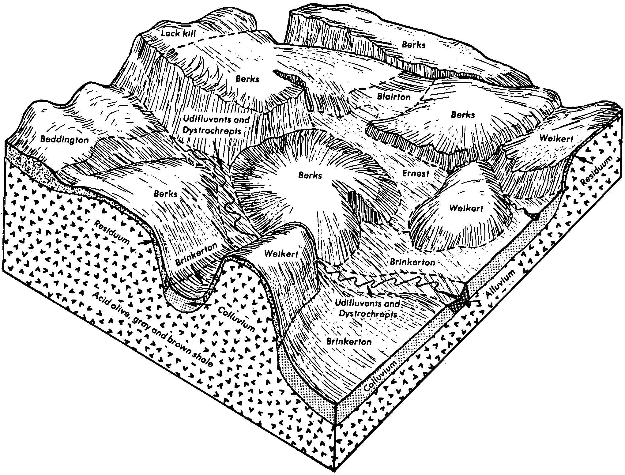
Calvin-Leck Kill shaly silt loams, 3 to 8 percent slopes, moderately eroded | ClB2 | 39436 | 540717 | l4nh | pa043 | 1967 | 1:15840 |
Calvin-Leck Kill shaly silt loams, 8 to 15 percent slopes, moderately eroded | ClC2 | 17634 | 540718 | l4nj | pa043 | 1967 | 1:15840 |
Calvin-Leck Kill shaly silt loams, 0 to 3 percent slopes | ClA | 1635 | 540716 | l4ng | pa043 | 1967 | 1:15840 |
Leck Kill channery silt loam, 8 to 15 percent slopes | LegC | 543 | 737615 | srk1 | pa043 | 1967 | 1:15840 |
Leck Kill-Calvin channery silt loams, 15 to 25 percent slopes | LfgD | 498 | 737616 | srk2 | pa043 | 1967 | 1:15840 |
Leck Kill channery silt loam, 3 to 8 percent slopes | LegB | 353 | 737614 | srk0 | pa043 | 1967 | 1:15840 |
Leck Kill channery silt loam, 8 to 25 percent slopes, very stony | LggD | 115 | 737619 | srk5 | pa043 | 1967 | 1:15840 |
Leck Kill-Calvin channery silt loams, 25 to 50 percent slopes | LfgF | 75 | 737617 | srk3 | pa043 | 1967 | 1:15840 |
Leck Kill channery silt loam, 0 to 8 percent slopes, very stony | LggB | 34 | 737618 | srk4 | pa043 | 1967 | 1:15840 |
Leck Kill channery silt loam, 25 to 60 percent slopes, extremely stony | LkF | 4132 | 1591158 | 1qdqp | pa051 | 2005 | 1:24000 |
Leck Kill channery silt loam, 8 to 25 percent slopes, extremely stony | LkD | 2548 | 1591157 | 1qdqn | pa051 | 2005 | 1:24000 |
Leck Kill channery silt loam, 15 to 25 percent slopes | LeD | 1040 | 1591094 | 1qdnm | pa051 | 2005 | 1:24000 |
Leck Kill channery silt loam, 8 to 15 percent slopes | LeC | 625 | 1591093 | 1qdnl | pa051 | 2005 | 1:24000 |
Leck Kill channery silt loam, 0 to 8 percent slopes, extremely stony | LkB | 480 | 1591156 | 1qdqm | pa051 | 2005 | 1:24000 |
Leck Kill channery silt loam, 3 to 8 percent slopes | LeB | 475 | 1591092 | 1qdnk | pa051 | 2005 | 1:24000 |
Calvin-Leck kill channery silt loams, 3 to 8 percent slopes | CkB | 7044 | 544842 | l8yk | pa057 | 1999 | 1:24000 |
Leck Kill channery silt loam, 25 to 60 percent slopes, extremely stony | LkF | 451 | 1720957 | 1vrsr | pa063 | 2012 | 1:24000 |
Leck kill very stony silt loam, 8 to 25 percent slopes | LfC | 1989 | 541309 | l58l | pa075 | 1976 | 1:20000 |
Leck kill shaly silt loam, 8 to 15 percent slopes | LeC | 1001 | 541308 | l58k | pa075 | 1976 | 1:20000 |
Leck kill shaly silt loam, 3 to 8 percent slopes | LeB | 832 | 541307 | l58j | pa075 | 1976 | 1:20000 |
Leck kill channery silt loam, 8 to 15 percent slopes | LegC | 309 | 1397942 | 1hxnx | pa075 | 1976 | 1:20000 |
Leck kill channery silt loam, 3 to 8 percent slopes | LegB | 119 | 1397941 | 1hxnw | pa075 | 1976 | 1:20000 |
Leck Kill-Calvin channery silt loams, 15 to 25 percent slopes | LfgD | 116 | 1397943 | 1hxny | pa075 | 1976 | 1:20000 |
Leck kill channery silt loam, 0 to 3 percent slopes | LegA | 34 | 1397940 | 1hxnv | pa075 | 1976 | 1:20000 |
Leck kill channery silt loam, 8 to 25 percent slopes, very stony | LggD | 25 | 1397944 | 1hxnz | pa075 | 1976 | 1:20000 |
Leck kill channery silt loam, 8 to 15 percent slopes | LkC | 2297 | 296446 | 9ygs | pa079 | 1974 | 1:20000 |
Leck kill channery silt loam, 3 to 8 percent slopes | LkB | 2109 | 296445 | 9ygr | pa079 | 1974 | 1:20000 |
Leck kill channery silt loam, 15 to 25 percent slopes | LkD | 1155 | 296447 | 9ygt | pa079 | 1974 | 1:20000 |
Leck kill channery silt loam, 8 to 15 percent slopes | LkC | 23891 | 539096 | l2z6 | pa081 | 1981 | 1:20000 |
Leck kill channery silt loam, 15 to 25 percent slopes | LkD | 21031 | 539097 | l2z7 | pa081 | 1981 | 1:20000 |
Leck kill channery silt loam, 3 to 8 percent slopes | LkB | 11950 | 539095 | l2z5 | pa081 | 1981 | 1:20000 |
Leck Kill channery silt loam, 25 to 50 percent slopes | LeF | 30377 | 539913 | l3tk | pa083 | 1984 | 1:20000 |
Leck Kill channery silt loam, 15 to 25 percent slopes | LeD | 17595 | 539912 | l3tj | pa083 | 1984 | 1:20000 |
Leck Kill channery silt loam, 8 to 15 percent slopes | LeC | 5842 | 539911 | l3th | pa083 | 1984 | 1:20000 |
Leck Kill channery silt loam, 3 to 8 percent slopes | LeB | 1221 | 539910 | l3tg | pa083 | 1984 | 1:20000 |
Leck kill channery silt loam, 2 to 8 percent slopes | LkB | 2710 | 296320 | 9ybq | pa089 | 1975 | 1:20000 |
Leck kill channery silt loam, 8 to 15 percent slopes | LkC | 2173 | 296321 | 9ybr | pa089 | 1975 | 1:20000 |
Leck kill channery silt loam, 15 to 25 percent slopes | LkD | 743 | 296322 | 9ybs | pa089 | 1975 | 1:20000 |
Leck Kill shaly silt loam, 8 to 15 percent slopes | LnC | 125 | 539009 | l2wd | pa093 | 1980 | 1:20000 |
Leck Kill shaly silt loam, 15 to 25 percent slopes | LnD | 100 | 539010 | l2wf | pa093 | 1980 | 1:20000 |
Leck Kill shaly silt loam, 3 to 8 percent slopes | LnB | 83 | 539008 | l2wc | pa093 | 1980 | 1:20000 |
Leck kill shaly silt loam, 8 to 15 percent slopes | LnC | 3668 | 539651 | l3k3 | pa097 | 1980 | 1:20000 |
Leck kill shaly silt loam, 3 to 8 percent slopes | LnB | 2767 | 539650 | l3k2 | pa097 | 1980 | 1:20000 |
Leck kill shaly silt loam, 15 to 25 percent slopes | LnD | 641 | 539652 | l3k4 | pa097 | 1980 | 1:20000 |
Leck Kill channery loam, 15 to 25 percent slopes | LeD | 12684 | 2432938 | 2mnnw | pa105 | 1953 | 1:24000 |
Leck Kill channery loam, 8 to 15 percent slopes | LeC | 4968 | 2432935 | 2mnns | pa105 | 1953 | 1:24000 |
Leck Kill channery loam, 8 to 25 percent slopes, extremely stony | LesD | 292 | 2432950 | 2mnp8 | pa105 | 1953 | 1:24000 |
Leck Kill channery loam, 3 to 8 percent slopes | LeB | 35 | 2440173 | 2mx68 | pa105 | 1953 | 1:24000 |
Leck kill channery silt loam, 8 to 15 percent slopes | LeC | 19129 | 539738 | l3mx | pa107 | 1977 | 1:20000 |
Leck kill channery silt loam, 3 to 8 percent slopes | LeB | 19122 | 539737 | l3mw | pa107 | 1977 | 1:20000 |
Leck kill shaly silt loam, 8 to 15 percent slopes | LnC | 3734 | 540830 | l4s4 | pa109 | 1980 | 1:20000 |
Leck kill shaly silt loam, 3 to 8 percent slopes | LnB | 2816 | 540829 | l4s3 | pa109 | 1980 | 1:20000 |
Leck kill shaly silt loam, 15 to 25 percent slopes | LnD | 592 | 540831 | l4s5 | pa109 | 1980 | 1:20000 |
Leck kill soils, 25 to 60 percent slopes | LmF | 18332 | 542101 | l634 | pa111 | 1977 | 1:20000 |
Leck kill channery silt loam, 8 to 15 percent slopes | LeC | 7445 | 542097 | l630 | pa111 | 1977 | 1:20000 |
Leck kill channery silt loam, 15 to 25 percent slopes | LeD | 6951 | 542098 | l631 | pa111 | 1977 | 1:20000 |
Leck kill very stony silt loam, 8 to 25 percent slopes | LkD | 5394 | 542100 | l633 | pa111 | 1977 | 1:20000 |
Leck kill channery silt loam, 3 to 8 percent slopes | LeB | 4243 | 542096 | l62z | pa111 | 1977 | 1:20000 |
Leck kill very stony silt loam, 3 to 8 percent slopes | LkB | 772 | 542099 | l632 | pa111 | 1977 | 1:20000 |
Leck kill shaly silt loam, 3 to 8 percent slopes | LnB | 181 | 540929 | l4wb | pa119 | 1980 | 1:20000 |
Leck kill shaly silt loam, 8 to 15 percent slopes | LnC | 160 | 540930 | l4wc | pa119 | 1980 | 1:20000 |
Leck Kill channery silt loam, 8 to 25 percent slopes, extremely stony | LkD | 2139 | 544679 | l8s9 | pa129 | 2003 | 1:24000 |
Leck Kill channery silt loam, 8 to 15 percent slopes | LeC | 545 | 544681 | l8sc | pa129 | 2003 | 1:24000 |
Leck Kill channery silt loam, 0 to 8 percent slopes, extremely stony | LkB | 415 | 544678 | l8s8 | pa129 | 2003 | 1:24000 |
Leck Kill channery silt loam, 3 to 8 percent slopes | LeB | 279 | 544680 | l8sb | pa129 | 2003 | 1:24000 |
Leck Kill channery silt loam, 25 to 60 percent slopes | LeF | 41866 | 539188 | l325 | pa607 | 1986 | 1:20000 |
Leck Kill channery silt loam, 15 to 25 percent slopes | LeD | 6276 | 539187 | l324 | pa607 | 1986 | 1:20000 |
Leck Kill channery silt loam, 8 to 15 percent slopes | LeC | 2624 | 539186 | l323 | pa607 | 1986 | 1:20000 |
Leck Kill channery silt loam, 3 to 8 percent slopes | LeB | 2171 | 539185 | l322 | pa607 | 1986 | 1:20000 |
Leck Kill-Rayne silt loams, 15 to 30 percent slopes | 15D | 2302 | 521248 | khdg | va155 | 1981 | 1:15840 |
Leck Kill-Rayne silt loams, 7 to 15 percent slopes | 15C | 1852 | 521247 | khdf | va155 | 1981 | 1:15840 |


